Licensed
& Insured

Our Technology

Advanced drone technology for every project needs.

Cutting-edge drone technology

Each of our drones is equipped with specialized features designed to meet specific project requirements. From thermal imaging, to agricultural insights.

Mavic 3 Thermal

Precision in Thermal Imaging

Mavic drone photo

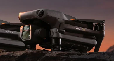
Ideal for detecting heat anomalies, hidden issues, and doing emergency inspections. Its high-resolution thermal sensor, delivers real-time imaging.

Key Features

  • 640x512 px thermal resolution for detailed thermal inspections
  • Simultaneous thermal & visual imaging for comprehensive analysis
  • Spot and area temperature measurement for early issues detection

Best For

  • Roof inspections for leaks and isolation failures
  • Electrical and solar panel open field audits
  • Emergency response and damage assessment after natural disasters
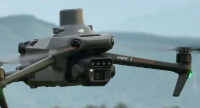
Mavic 3 Enterprise

Advanced Aerial Infrastructure Inspections

Mavic drone photo

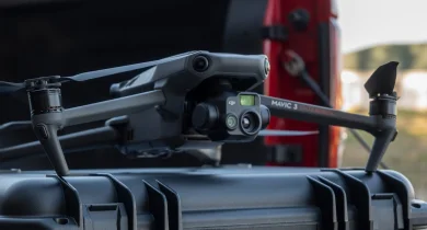
Designed for commercial and industrial inspections where precision is key. Its high-resolution zoom camera make it ideal for inspecting hard-to-reach areas.

Key Features

  • 20MP camera with 56x hybrid zoom for detailed thermal inspections
  • RTK (Real-Time Kinematic) positioning for centimeter-level accuracy
  • Advanced obstacle detection for safe and efficient flights

Best For

  • Infrastructure inspections (bridges, towers, and pipelines)
  • Construction progress monitoring
  • Mapping and surveying large industrial sites

Mavic 3 Multispectral

Agriculture & Environmental Monitoring

Mavic drone photo

Built for agricultural and environmental analysis, capturing highly detailed multispectral data to help you optimize crop health and land management.

Key Features

  • 4-band multispectral imaging (Green, Red, Red Edge, Near-Infrared)
  • Real-time NDVI analysis for crop health monitoring
  • High-precision GPS for accurate, detailed land mapping

Best For

  • Environmental monitoring and land assessment
  • Precision agriculture and crop analysis
  • Agricultural forestry and resources management

Tailored Service Packages

Essential Inspection Package

Mavic 3 Thermal Drone

Ideal for rapid assessments and basic building inspections.

  • Aerial thermal drone inspection
  • Basic data analysis report
  • Quick turnaround time

Infrastructure Pro Package

Mavic 3 Enterprise Drone

Designed for detailed structural and commercial inspections.

  • High-resolution inspection imaging
  • Detailed structural analysis report
  • Real-time, RTK precision monitoring

Agriculture & Environmental

Mavic 3 Multispectral

Perfect for land management and environmental monitoring.

  • Multispectral drone inspection
  • In-depth crop health analysis report
  • Land mapping & recommendations

Frequently Asked Questions

What guarantees do you offer?

We deliver precision, reliability, and results you can trust. Our inspections and data analysis are conducted by Florida-licensed qualifiers, ensuring the highest professional standards. We adhere to Florida's strict building codes, recognized as some of the toughest in the Nation due to the state's exposure to hurricanes, tornadoes, coastal winds, and severe weather conditions.

Where is the data processed?

Our technical command center is strategically based in Florida, where all data is analyzed and processed by experts who understand the complexities of these environmental challenges. This ensures you receive a report that is not just accurate but built on a foundation of strict compliance and in-depth expertise.

How long do inspections take?

The time required varies based on the scope and complexity of a project. Residential inspections typically take between 30 minutes to 2 hours, with comprehensive reports delivered within 24-48 hours. Commercial inspections and more complex analysis may take 3 to 5 business days to ensure every detail is evaluated and processed by our certified specialists.

Will my property be recorded?

Yes, with your authorization. Our drone inspections capture high-resolution images and videos exclusively for analytical purposes. All recordings are handled securely and reviewed only by our qualified professionals. Your privacy and data protection are always our top priority.

Where do you offer your services?

While our technical command center operates from Florida, services are available across the United States, Canada, and Latin America. All captured data is processed and analyzed under the same high standards that meet Florida's rigorous compliance codes, ensuring accurate and reliable results for every project.

Get a custom quote

Based on your project needs. Our experts are ready to help you select the right solution. Contact us for a personalized consultation and quote.

Get a Quote